2. Getting to know the interface#
The MISSIONPLANNER user interface is divided into the following main elements:
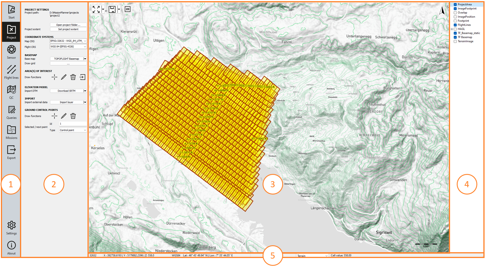
Item |
Element |
Description |
|---|---|---|
1 |
Contains links to MISSIONPLANNER’s main pages. |
|
2 |
Contains links to the page’s related content, settings, or additional features. |
|
3 |
The main area where you perform most actions related to creating and modifying your flight plan. |
|
4 |
Displays the map layers and allows you to manage them. |
|
5 |
Displays coordinates and terrain altitude for the current mouse position. |
2.1. Navigation bar#
The Navigation bar contains the following links to MISSIONPLANNER’s main pages:
-
 Start
Includes commands for creating new projects or opening existing ones. The last opened projects are available via tiles with a thumbnail image.
Start
Includes commands for creating new projects or opening existing ones. The last opened projects are available via tiles with a thumbnail image. -
 Project
Includes settings that you can configure for the currently open project. Here you can also draw the area of interest (AOI) and ground control points (GCP).
Project
Includes settings that you can configure for the currently open project. Here you can also draw the area of interest (AOI) and ground control points (GCP). -
 Sensor
Includes options for selecting and configuring the camera or system that will be used in your project.
Sensor
Includes options for selecting and configuring the camera or system that will be used in your project. -
 Flight lines
Contains parameters for configuring basic metrics, calculating altitude and creating/managing flight lines.
Flight lines
Contains parameters for configuring basic metrics, calculating altitude and creating/managing flight lines. -
 QC (Quality Control)
Contains tools to assist you in evaluating if your flight plan meets the project requirements.
QC (Quality Control)
Contains tools to assist you in evaluating if your flight plan meets the project requirements. -
 Queries
Contains tools for extracting information from your flight plan according to different parameters.
Queries
Contains tools for extracting information from your flight plan according to different parameters. -
 Missions
Contains options for creating/managing projects divided into individual missions.
Missions
Contains options for creating/managing projects divided into individual missions. -
 Export
Contains options for exporting your flight plan to other formats.
Export
Contains options for exporting your flight plan to other formats. -
 Settings
Contains options for configuring MISSIONPLANNER options such as display settings, flight lines and elevation data.
Settings
Contains options for configuring MISSIONPLANNER options such as display settings, flight lines and elevation data. -
 About
Displays information on the current MISSIONPLANNER version (including new features and bug fixes) and contains direct links to the:
About
Displays information on the current MISSIONPLANNER version (including new features and bug fixes) and contains direct links to the:Online documentation
Latest release - direct download of the latest software installer (.exe)
Online reference of the software program
2.2. Secondary sidebar#
The secondary sidebar appears for the following Navigation bar items:
2.3. Workspace#
The workspace is the main area where you perform most actions related to creating and modifying your flight plan. You can interact with the workspace through the secondary sidebar and layers panel.
It offers quick access to different viewing options, e.g. the 3D view mode and the setting of the map scale for your project.
2.4. Layers panel#
Displays the map layers and allows you to hide or display specific layers by selecting or clearing the respective checkbox. Double-click or right-click on any layer to see additional functions you can perform on the layer, such as configuring and customizing layer properties.
Hint
To change the stacking order of the layers between front and back, drag each layer up or down as required.
2.5. Status bar#
The Status bar displays the following information:
EPSG Code of the map coordinate system
mouse position X, Y and Z coordinates/terrain altitude [ft]
coordinate reference system (CRS)
-
latitude and longitude of the current mouse position

-
In addition, a layer can be selected from the available pixel layers. In the last field, the cell value on the mouse position will be displayed.

2.6. Keyboard shortcuts#
Shortcut |
Action |
|---|---|
CTRL+S |
Save the project. |
Ctrl+Shift+S |
Save the project with a new name. |
CTRL+L |
Open the log. |
CTRL+D |
Download the SRTM for current location. |
CTRL+P |
Repaint map canvas. |
CTRL+U |
Unselect everything. |
CTRL + |
Zooms in on the map. |
CTRL - |
Zooms out on the map. |
CTRL+mouse wheel |
Enables smoother zooming on the map. |
ESC |
Terminate the current action/function. |
Backspace |
The last drawn marking (such as flight line or AOI) will be deleted. |
F1 |
Open the online documentation. |
F2 |
Activate the visibility of all layers. |
F3 |
Hide all vector layers. |
F4 |
Hide all raster layers. |
F5 |
Keep visible the layers
while hiding all other vector layers. |
F6 |
Keep visible the layers
while hiding all other vector layers. |
F7 |
Keep visible the layer
while hiding all other raster layers. |